
 Challenge
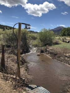
After a wildfire in the nearby mountains increased the likelihood of water run-off into the town of La Veta, it became necessary to know when a flood event was approaching to give citizens enough time to evacuate.
Solution
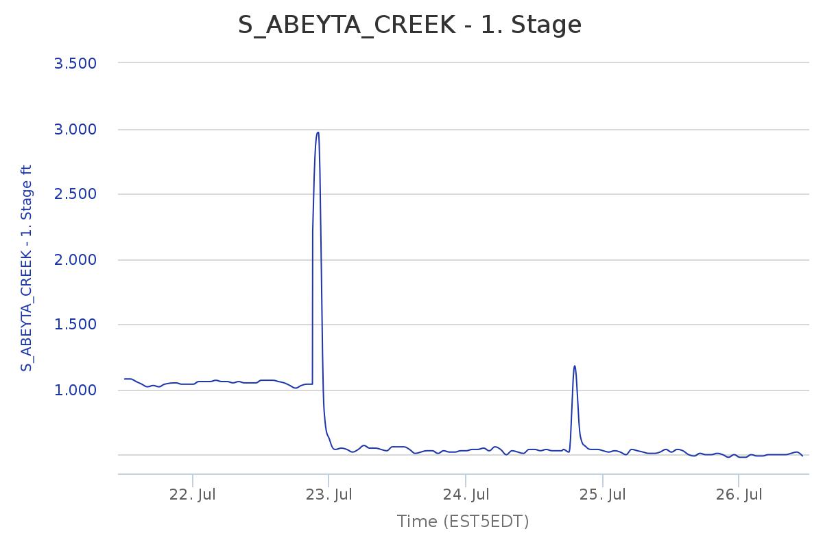
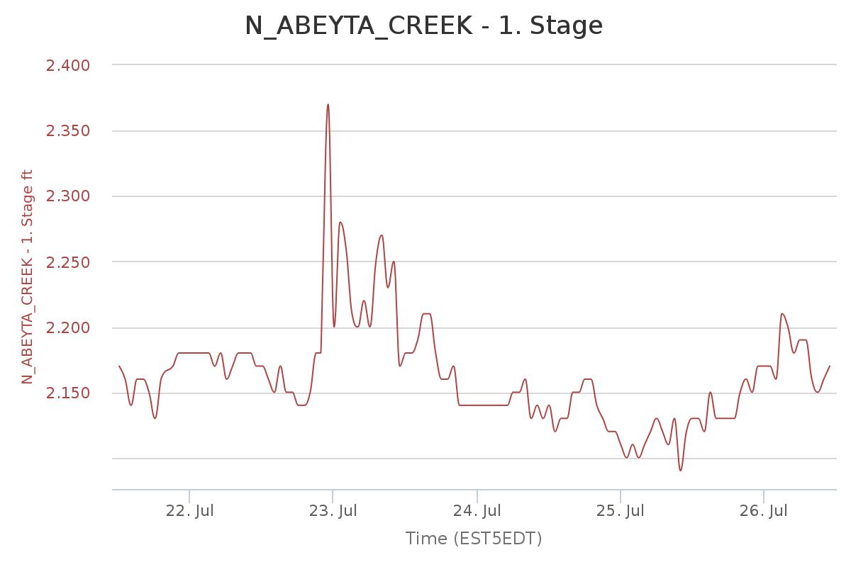
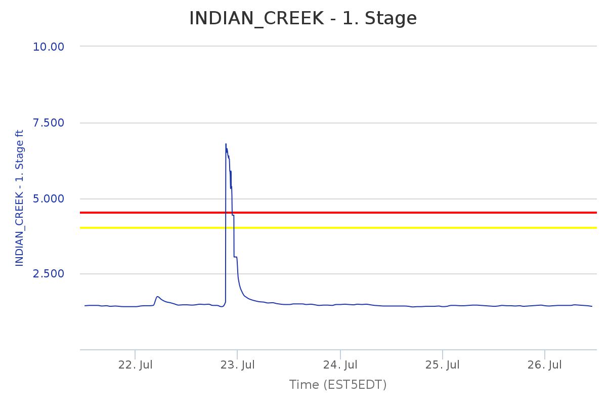
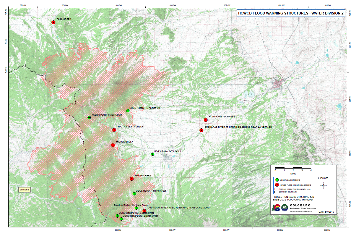
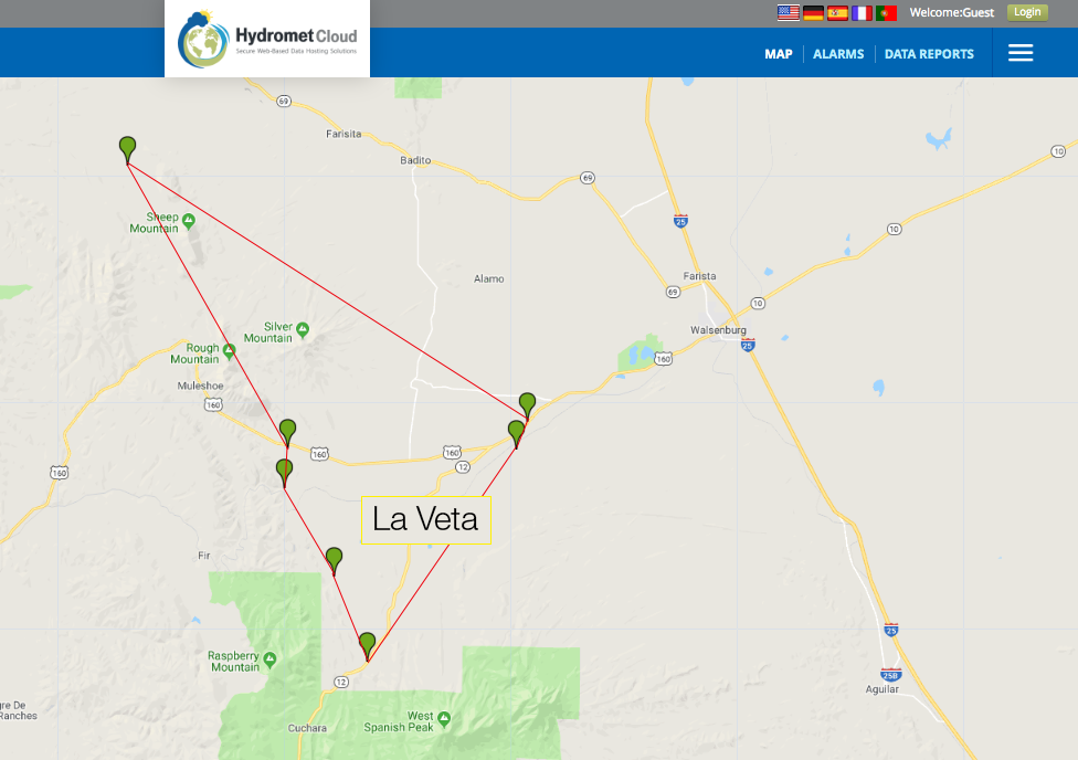
Seven stations, each equipped with SUTRON and OTT technology, were set up within a 13-mile radius of La Veta to measure precipitation, water level, and water surface velocity.
Benefits
With data from these stations compiled into a watershed data matrix, the town is able to see when water from multiple areas is rising to a dangerous level in order to alert citizens.
 Since summer was fast approaching, which is the season that typically encounters intense monsoons in Southern Colorado, the Mayor acted quickly. He pulled in the Colorado Division of Water Resources, which had experience setting up surface water monitoring field stations in Colorado, to help with the set-up and assume maintenance responsibilities for the following five years before turning the project back to the town of La Veta.
The Division of Water Resources has been responsible for water administration rights for Colorado for over 100 years. Their Chief of Hydrographic Services, Matt Hardesty, currently helps oversee over 600 surface water monitoring sites including stream gages and reservoirs, with the goal of understanding the current water supply and how to allocate it for purposes like crop irrigation.
Mayor Brgoch and Hardesty teamed up with Huerfano County Water Conservancy District board member Michael White to help conceptualize and design the system of gages for when tributary streams reached flood state. Their main goal was to buy extra time to warn their citizens, as well as understand what proper water level thresholds should be used to trigger alarms. Financing for the project was administered by the Huerfano County Water Conservancy District and came from the District, the Colorado Division of Water Resources, Colorado Department of Homeland Security and Emergency Management, Huerfano County, and the Colorado Water Conservation Board.
With a defined plan, the team engaged SUTRON, which the Colorado Division of Water Resources was familiar with due to a positive working relationship with SUTRON beginning in 1985. SUTRON joined the OTT HydroMet organization in 2015.
Through OTT HydroMet Territory Manager John Humphreys, the team learned of flood warning packages available that included OTT and SUTRON products. The group began to pinpoint suitable site locations for the future stations, and then ordered the stations with the technology they would need. With streamlined help from OTT HydroMet, the team received their pre-wired and pre-mounted panels in 30 days and simply had to install and briefly fine-tune each of the seven enclosures in its designated location.
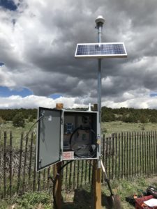 Each SUTRON NEMA enclosure contains the following:
• 1 OTT Radar Level Sensor (RLS)
• 1 OTT Surface Velocity Radar (SVR) 100
• 1 Lufft WS100 Radar Precipitation Sensor/Smart Disdrometer
• 1 SUTRON XLink 500 Data Transmitter
• 1 Solar Panel
Each station measures precipitation, water level, and water surface velocity. Given how intense incoming monsoons can be, it’s important to know if a significant amount of water is approaching, how high it is, and how fast it is moving downstream. The precipitation sensors have been very valuable to the National Weather Service to verify actual precipitation during or after the issuance of precipitation and flooding watches and warnings.
The team compiles data from six of the seven stations into a matrix (with one being too far Northwest to include in the La Veta area), to understand how water from each area in the 13 miles they span across will affect the others during rain events. Four of these locations give a look into the burn scar above La Veta, while others surround nearby municipalities. Together, these stations provide a complete picture of the local area – for example, one station with surpassed thresholds may not be cause for alarm, but three or more could signal a serious flood approaching. The matrix allows human oversight to double check the data they see and allows the stations to work together.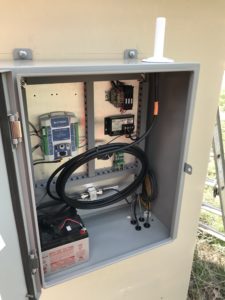
 “The goal of this system is to provide timely information to emergency managers without placing them in harm’s way to make visual observations. It’s like having eyes in the field.”
– Matt Hardesty, Colorado Division of Water Resources
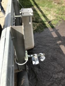
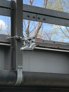
The OTT RLS and OTT SVR 100 fixed to a bridge over flowing water.

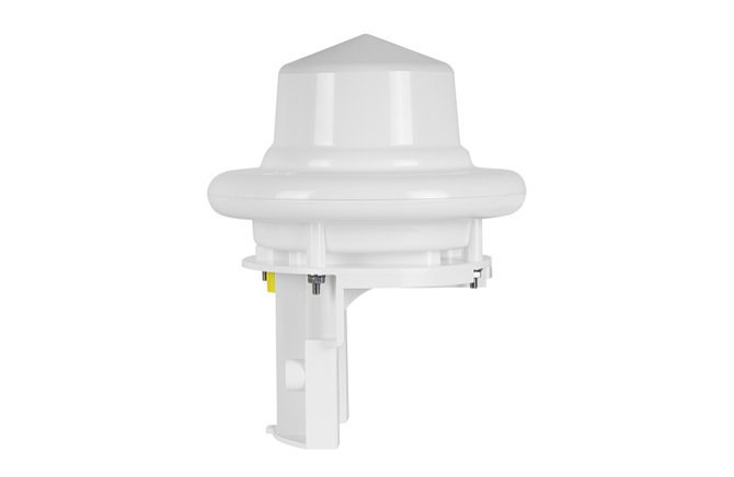
OTT Radar Level Sensor (RLS)
Non-contact level sensor for long term surface water monitoring.
Lufft Smart Disdrometer - WS100 Radar Precip. Sensor
Real-time measurement of liquid and non-liquid precipitation and intensity, and virtually maintenance-free.
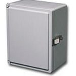
SUTRON NEMA Enclosure - NEMA 4
Water-tight glands, external mounting feet, and seams that are continuously welded.
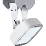
OTT Surface Velocity Radar - SVR 100
Simple, non-contact, compact sensor designed for measuring flow in open channels and rivers.
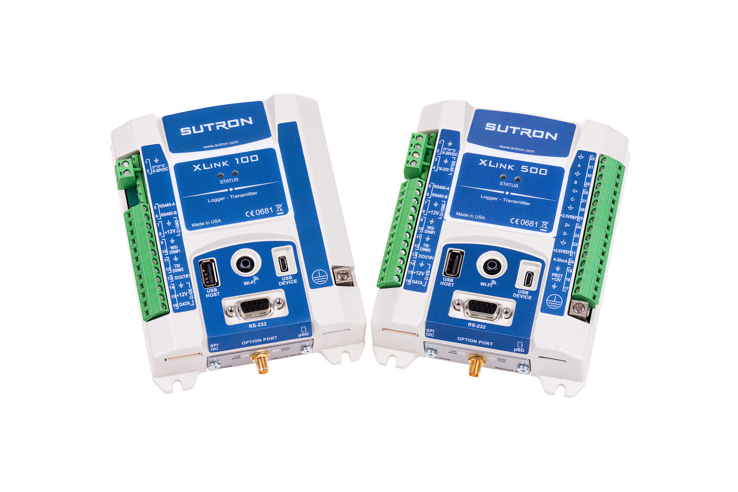
SUTRON Data Transmitter - XLink 500
Multi-Sensor input logger with data transmission via lridium or cellular.
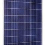
SUTRON Solar Panel - 2 Watts to 120 Watts
Works for a great variety of attachment methods and mounting spaces.
